Wednesday, April 17, 2013

The Wetter the Better...


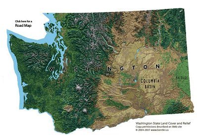
Washington State Geographic Map
When people think of Seattle and the Pacific Northwest, they often thing of rain, gray skies, and cold weather.  When in fact, they are correct.  Well half correct.  The state of Washington is known for its lush, beautiful green landscapes filled with evergreen trees and wet undergrowth.  But these common beliefs are only about one third the state.  From the Olympic coast to western slopes of the Cascades, the Seattle and Puget Sound areas are what most people think of in terms of the Pacific Northwest.  The western third of the state is very moist, with high amounts of precipitation each year.  Some of the highest in the continental United States.  In fact, the Olympic National Park rainforest with the highest amount of precipitation in the northern hemisphere is located on the Olympic peninsula.

Left & Right, Black & White, Wet & Dry...

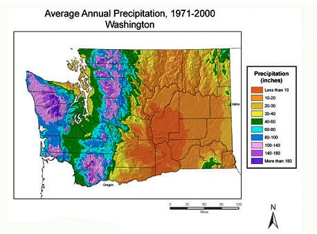
Amount of Precipitation, Washington State


There are several reasons as to why the western third of Washington State is so wet.  One of which is the rain shadow effect.  As the moist cool air flows in from the Pacific Ocean, the Olympic peninsula and Puget Sound capture all that moisture.  This occurs not simply because the weather rolls inland, but mostly in part to the two mountain ranges that surround the Seattle-Tacoma area.  The Olympic mountains first to the west, and the Cascade Mountains to the east.  The abrupt increase in elevation from sea-level to the tops of the Olympic Mountains causes the already cool pacific air to quickly reach their due point.  As the cold moist air is forced over the mountains and cools, the water in the air is released on the Olympic Mountains and in the Olympic National Park.  This is why this part of Washington is known for its high precipitation amounts.  As the weather continues east towards the Puget Sound and the Seattle area, the air quickly descends, it mixes with the cool moist air being blow in through the Puget sound from the north by Victoria, British Columbia.  This helps to keep the moisture in the air that travels through the Puget Sound.  This is where the air again rises quickly up the western slope of the Cascades, reaching its due point quickly, allowing the rain to fall on the western slopes and Puget Sound areas of Washington.  The Olympic Peninsula receives around a high of 200 inches of precipitation a year, where on the eastern side of the state in Spokane is typically less than 20 inches of precipitation a year.
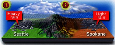

Seattle to Spokane
Now this is where the moisture stops, and the nomenclatures about the Pacific Northwest with them.  If you were to drive on I-90 over the Cascades from Seattle east towards Spokane, Washington, you would notice how the climate completely changes.  The eastern two thirds of Washington State are like most of California, Nevada, Utah, and Colorado; very dry and arid.  This is due to the Cascade rain shadow; the Columbia River Basin stays flat and dry.  The biggest rains and weather differences come when the prevailing winds blow from the south. 


Air Mass Flow Diagram

The moist air in the Pacific Northwest is a colder air.  It comes for the Maritime Polar air that flows in from the north Pacific.  This keeps the temperatures relatively cool and consistent, but is also the reason for all the rain.  Since it’s a maritime air mass, this infers that it will be loaded with moisture unlike continental air masses.
As the maritime polar air mass (cold front) flows towards the Pacific Northwest coast, it converges with the maritime tropical air mass (warm front), the cold front overtakes the warm front and forms an occluded front right over the pacific north west.  This occluded front creates the possibility of a high amount of precipitation to be produced.  This is the case in the Pacific Northwest and why Seattle and the surrounding areas are known for their excessive rain.  as the front moves east, it reaches down into Oregon and northern California. 


 http://www.theweatherprediction.com/weatherpapers/118/ 
http://cses.washington.edu/cig/pnwc/pnwc.shtml

Monday, March 11, 2013

Soils Reveal an Ancient Past.

When people think of the Pacific Northwest, they often thing of how lush and green everything is.  Pine trees like Douglas-Fir and conifer trees are just amount the many plants that give Washington State the title, the “Evergreen State.”  The western slope of the Cascade mountain range is home to a very large and dense population of people.  All these people have established themselves on over 1600 different types of soils.  A lot of these soils have been created by historic geographical influences such as volcanic activity and glacial movement.  

http://wsumgtc.files.wordpress.com/2013/02/tokul-map.gif
Areas where Tokul soils are. (in green))
Tokul Soils
Due to the subduction zone (where the Juan de Fuca plate is pushing under the North American plate) located directly under the western half of Washington State, volcanic activity has over time deposited layer upon layer of ash.  This ash has settled onto the western cascades, along the Puget Trough, from Seattle to the Canadian border.  These soils are called Tokul soils.  Tokul soils are primarily influenced by the ash left by the volcanic activity.
The process of gleization (development of extensive soil organic layer over a layer of chemically reduced clay) and glacial movements helped to create these Tokul soils.  Just as gleization is classified, Tokul soils are somewhat poorly drained of water from the high amounts of precipitation on the western slopes of the Cascades, and glacial influences.  It possesses moderate permeability above the cemented pan, and very slow permeability below the cemented pan.  Permiability is how well the water is able to pass through the soil as it flows downward to the water table.  Tokul is considered to be amorphic, or having no specific shape or structure. The fertile nature and properties of Tokul soils make is some of the most productive soils in the world; making it suitable for the production of crops, forestry (timber), livestock grazing, and even recreation.
http://landslides.usgs.gov/recent/archives/nisqually/images/A1.jpg
Tokul landslide on steep slop due to brittle nature.
 But due to its very moist nature, the soil is very unstable.  Tokul is a part of glacial soils (soils left behind from the retreating of glaciers).  As it was mentioned how moist these deposited soils are, they often need assistance in the dewatering process.  A few examples of areas of glacial soils and erosion from glaciers are the banks of Lake Washington, Cedar River, May Creek and Coal Creek.


Photograph of the profile of a typifying pedon of Tokul soil series.
Tokul Soil Profile
  

Tokul Horizons
O-Horizon = 1-2 inches
A-Horizon = 2-6 inches, Andic soil properties from 2 to 33 inches
B-Horizon = 6-62 inches, Redox concentrations at 17 inches with aquic conditions (depletions with chroma of 2 and concentrations) at 33 inches, Cemented pan at 33 inches.

Tokul Soil Profile
Surface layer: organic material
Subsurface layer: very dark grayish brown gravelly loam Subsoil - upper: dark brown gravelly loam Subsoil - lower: light yellowish brown gravelly loam Substratum: light brownish gray and dark gray gravelly sandy loam (very hard, dense glacial till cemented by a combination of iron, aluminum, and organic matter)

(click here 
https://soilseries.sc.egov.usda.gov/OSD_Docs/T/TOKUL.html )


Loess Soils
Palouse Region map, and areas of Loess deposits
The Palouse Region of southeastern Washington, northeastern Oregon, and northwestern Idaho is home to completely different fertile soils, Loess soils.  These soils are also found in Tokul soils.  Loess soils are mixed with clay and give off a yellowish color.  These loess soils are also left over from retreating glaciers.  The difference between Loess soils and Tokul soils is simply precipitation.  The heavy rains on the western slopes of the Cascades keep the Tokul soils very moist, whereas the eastern side of the Cascades is must drier and more arid.  Loess means “loose” in German, which is where the name is applied.  Loess soils are formed by wind-blown accumulation of silt.  This silt is comprised of Aeolian sediments.  This silt is a source of rich nutrients and perfect for growing wheat, lentils, and peas in the Palouse Region.  
The beautiful farmland of the Palouse Region
Tokul soils and Loess soils are great examples of why the Pacific Northwest is a lush and fertile area.  It is also evidence of major land changes from glacier formations from the ancient past.


Work Cited.


Gleization: Geography-Dictionary.org. n.d. WEB. 9 March 2013. <http://geography.geography-dictionary.org/Physical-Geography-Dictionary/Gleization>.

Howe, Alicia. Soil Types in Washington State. n.d. WEB. 9 March 2013. <http://www.ehow.com/list_6008741_soil-types-washington-state.html>.

Loess: wikipedia.org. n.d. WEB. 9 March 2013. <http://en.wikipedia.org/wiki/Loess>.

U.S. Department of Agriculture. National Cooperative Soil Survey: Tokul Survey. March 1999. WEB. 9 March 2013. <https://soilseries.sc.egov.usda.gov/OSD_Docs/T/TOKUL.html>.

—. Tokul -- Washington State Soil. n.d. WEB. 9 March 2013. <ftp://ftp-fc.sc.egov.usda.gov/NSSC/StateSoil_Profiles/wa_soil.pdf>.
 

Monday, February 18, 2013

Living Beneath a Sleeping Giant


The Pacific Northwest is one big conglomeration of geographic landforms and formations.  There is not one distinct form of land form construction.  One of the major and prominent forms of topography is the visible evidence of volcanic and geothermal activity.  Scattered along the Cascade mountain range is a series of dormant volcanoes; some of which are not so dormant. 
View of Pacific Northwest

Cascadia: The series of volcanos along the Cascade range though Oregon and Washington are referred to as Cascadia. The volcanic activity in Cascadia is a product of subduction, where the Juan de Fuca and the North American Plates are meeting.  The Juan de Fuca place is sinking below the North American plate just off the coast of Washington and Oregon.  This creates seismic activity and in turn causes magma to travel to the surface.  Though the likelihood of an eruption occurring in the Cascadia is unlikely, but when an eruption does happen, it is often violent.  There is a lot of seismic activity still accruing in the Pacific Northwest and is in need of monitoring every day. 

Juan de Fuca Subduction Zone Cross Section


Mount St. Helens:  Many of the dormant Volcanos are well known by most.  The most famous is Mount St. Helens.  At 8:32 Sunday morning, May the 18th, 1980, Mt. St. Helens erupted and amazed the world with its devastation and beauty.
Mount St. Helens Eruption

Mount Rainier: But is this the end of volcanic activity in the Pacific Northwest?  That is a matter of opinion.  Mount Rainier is currently being watched by the PNSN because of its constant seismic activity.  On a daily basis there is something occurring seismically from glacier movement to magma flows under the volcanos surface.  Rainier is the tallest mountain in the Cascade Range at 14,410ft above sea level.  But Rainier was once even taller than it is now.  There is evidence that like St. Helens, the edifice of Rainier collapsed during an eruption leaving behind a crater; that has over time rebuilt itself due to many eruptions.

Mount Rainier from Seattle
 
Hazards Awaits: Mount Rainier is considered to be the most threatening volcano in the Cascade mountain range.  When (not if) the next eruption occurs, the entire Seattle-Tacoma area is in high risk of Lahar and flooding post Lahar.  There is not much we can do to prevent an eruption.  The best that can be done at the moment is continued surveys and studies to remain aware of what is continuing to happen beneath the mountain surface.  

Areas of Impact from Rainier Eruption

Works Cited


Pacific Northwest Seismic Network. 2013. http://www.pnsn.org (accessed February 16, 2013).

United States Geological Service. 12 17, 2012. http://volcanoes.usgs.gov/volcanoes/mount_rainier (accessed February 16, 2013).

Wikipedia. February 12, 2013. http://en.wikipedia.org/wiki/Cascadia_subduction_zone (accessed February 16, 2013).


Wednesday, January 30, 2013

Pacific Northwest: GEOG 1202 Introduction

Hello all. I am Evan McKenna and I am choosing to do my semester long geological study of the Pacific Northwest and their geological characteristics. From the cascade mountains, to the Puget Sound, and the lush and vast divorce environment. I'm choosing to study thus region of North America because my family came from the Seattle area; and since my childhood, I have visited the Pacific Northwest and been intrigued with everything about the area. Over the next few months, I'm excited to relate the things learned in class and applying them to the area of the US that I love to visit and explore.